
Check out the Iller Creek Maintenance Page on Facebook for current conditions and updates.
Why ride Iller?
The standard loop gives riders the feel of a big mountain ride yet is within 15-20 mins of most Spokane residents. Riders will be treated to a challenging climb, sweeping views of the Palouse surrounded by rock spires, followed by an exhilarating 2-mile descent.
Getting There and Parking
The trailhead is in the southwest portion of Spokane Valley. It can be accessed from the Southern end of East Holman Road. Vehicles can be parked at the small cul-de-sac at the trailhead (no fee). There is an outhouse, but no running water.
Important Information
The trails in the Dishman Hills Conservation Area are multi-use, care should be taken to accommodate other users. There is typically heavy hiker traffic on the weekends. Expect traffic in both directions and always yield to other trail users. In addition, respect wildlife by giving them a wide corridor.
Many local bikers have adopted the use of bells to help alert other trail users and animals they are approaching. The bell of choice is Timber and can be found at all local bike shops.
https://www.mtbbell.com/about.html
Best Route
Ride in a clockwise direction: Climb East Ridge Trail to the summit of the Rocks of Sharon. Then West Fork Trail back to Holman Rd trailhead.
What to Expect
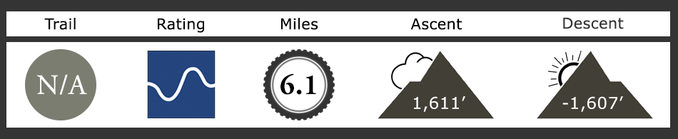
Iller Creek provides a hearty climb, outstanding views, and a fast (often technical) descent. Best ridden clockwise, this loop trail climbs over 1,200′ cresting on the ridge along Big Rock and skirting by the Rocks of Sharon.
Sometimes called Tower Mountain, this trail has a lot to offer mountain bikers, hikers, rock climbers, and wildlife. Expect traffic in both directions and take care to accommodate other users by yielding. This
is especially important during the final 1.5 miles, where the trail may be narrow, shadowed, and heavily vegetated.
Plan on a good workout and count on taking some breaks along the way. The first 1.75 miles keep you climbing steadily till you reach an optional trail that splits to the right. Named the Upper Valley trail, it is good for shorter loops, fading light, or avoiding snow late in the season. The next half mile leads you on a steep climb up to the ridgeline — a mostly concealed car in the foliage to the right signals you’re getting close. Here’s where the scenery really starts to impress.
Huge granite formations rise from the hillside contrasted by the rich green of pines. Definitely, a preferred area to stop, rest and take in the sights. As you follow the trail it weaves in and around these granite boulders. Hikers and rock climbers will be common along this section. Past Big Rock, the trail comes to a split. The loop continues to the right, but if you’re still enjoying the view you may want to walk your bike up the left route for a different perspective back along the ridge. Currently, this trail is deeply rutted and difficult to ride back down.
Once back on the loop begin a short moderate climb through shaded groves of trees. At a fork in the trail where going left goes up a steep hill choose the turn to the right. From here to the bottom anticipate a fast ride. The singletrack can often be steep, and visibility can be limited, and there are several sharp flat turns, so it’s recommended you keep things slower on your first visit.
Along the way, the route collects the optional trail described above, directly after you’ll make a sweeping 90˚ turn to the left. This is a signal to expect a more technical ride ahead. There’s a small creek crossing, bumps, and roots. Very fun technical areas that herald the section ahead. You’ll soon find yourself snaking over and around rocks as you navigate the narrow confines of a tight chute. Absolutely a fantastic and challenging section that culminates in an abrupt creek crossing.
The rest of the trail is straight forward. A smooth single and double track leads you back to the parking area. While this portion of the trail can be quite fast it is also frequented traveled by other trail users. Be ready to yield and expect limited visibility.
Additional Information
Best times to ride the main Iller loop are weekdays, early morning on the weekends, or at night.
Moose sightings aren’t uncommon especially early mornings between the ½ and ¾ marks of the climb. Be aware or ride with a bell to let them know you’re coming.
Trails off the main loop described above are not maintained. Many of the trails on the west side are old dirtbike trails that existed prior to the creation of the conservation area. These are fall line trails and typically very rutted out.
Dogs on a leash, please.
Outhouse at the trailhead, no running water.